
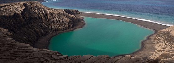
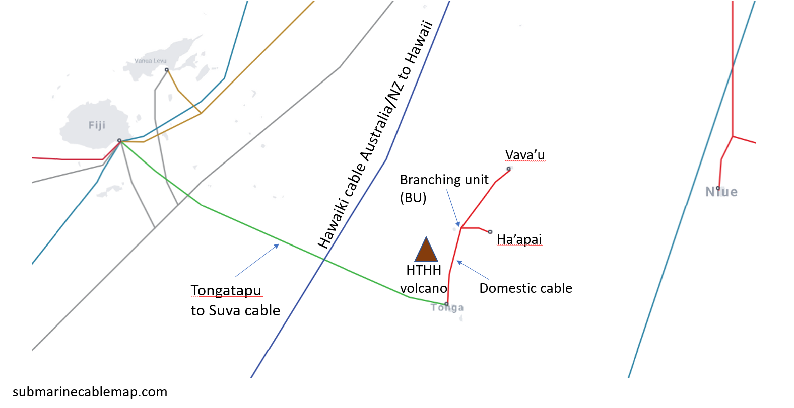
The 3000-year-old Kingdom of Tonga doesn’t often hit international headlines, but on 15 January this year it did, literally with a bang, when the Hunga Tonga Hunga Ha’apai volcano (or ‘Hunga’ for short) exploded at 4:06 (UTC), just past five in the afternoon local time. At 4:27 (UTC), a tsunami generated at the volcano hit a number of islands, including Tongatapu, the Ha’apai group, ‘Eua, and subsequently many more shores around the Pacific, causing destruction in many places and even tragedy in some. Videos of the waves arriving at Nuku’alofa, Tonga’s capital on Tongatapu, hit social media before Tonga’s only international cable failed between Tongatapu and Suva in Fiji. This cable runs around 50km south of Hunga. The domestic cable, much closer to Hunga, had already failed at 4:30 (UTC).
With no working satellite Internet backup links, Tonga was cut off almost completely, except for a small number of satellite phones and standalone communication systems operated by the few diplomatic missions in Tonga. Even these didn’t work well initially, owing to the impressive ash cloud over the islands, but what little they could communicate provided some assurance that almost all had survived and helped guide the initial relief effort.
Satellite operators and local telcos scrambled to throw whatever capacity was available at infrastructure that could be put into service at short notice. While this restored some level of communication via satellite, it was still far short of what Tonga needed, especially in terms of mobile data, which many Tongans depend on to receive remittances from family overseas. Having your harvest and fishing boats destroyed by a volcano is bad enough, but not being able to access money to buy food makes it a lot worse.
Dr Shane Reti, a New Zealand opposition Member of Parliament, asked for Starlink support — a bit of a technological stretch given Starlink’s current constellation and the distance to fibre-connected ground station locations. Starlink sent a team to Fiji to establish a gateway and sent a few dozen Dishy terminals to Tonga in anticipation of service. Unsurprisingly, this did not eventuate in time to make a difference for Tongatapu, let alone at a significant scale, even though they tried hard.
Why did the cable fail?
Meanwhile, I was curious as to why the cable had failed when it did, especially when I learned that the cable’s landing station on Tongatapu was intact, and Optical Time Domain Reflectometry (OTDR) detected a break in the cable 37km out to sea. Tsunamis as such don’t normally damage cables on the seafloor, and neither do a few centimetres of volcanic ash, unless the seafloor itself faults or material scrapes across it. My eye fell on a seamount just to the north of the point where the cable appeared to have severed. This would have shielded the cable from any direct impact from Hunga. But could this seamount have been the source of a submarine landslide in the aftermath of the eruption? There was certainly plenty of earthquake activity in the area to suggest that it could.
Shane Cronin, the University of Auckland’s very own Hunga expert, had had similar musings, albeit in the more general context of trying to understand and document the eruption and its aftermath. Together, we tried to piece together a timeline together but couldn’t come up with an event at Hunga that fit, however there was a M4.7 quake close to the seamount that USGS had picked up, and the timing seemed about right. No proof of course but, in Shane’s words, “… the plot thickens”. Shane involved other experts including volcanologist James White, civil engineer Colin Whittaker, and volcanologist and environmental fluid dynamicist Paul Jarvis.
My former student ‘Etuate Cocker put me in touch with Tonga Cable, and BigOceanData kindly made an account available so I could track the Reliance, the cable ship tasked with the repair. Reliance had to come from Port Moresby in Papua New Guinea and en route detoured to their depot in Apia, Samoa, to raid the shelves, so to speak. They sailed from Apia with about 80km of cable spares on board, a large part of which were borrowed spares from other cable systems in the region and arrived near Tongatapu on 2 February.
Repairing the cable
At this point, it’s useful to have a basic idea of how cable ships such as the Reliance fix cables that, like Tonga’s, are around 2000m below the sea. If visibility in the water allows, a Remotely Operated Vehicle (ROV) locates the cable and cuts it at the damage point, if it isn’t already completely severed. If visibility is poor or the cable is buried, the ship tows a sled with a cutter at the bottom across the seafloor at roughly a right angle to the cable route to perform the cut. This is known as a Cutting Drive (CD), or ‘drag’.
The ship then sails about 2000m to one side, repeats the sled operation with a grapnel hook rather than a cutter and brings one of the ends up to the surface. This is known as a Holding Drive (HD). There, the cable end gets tied to a buoy. The ship then repeats the procedure at the other end, except that they may skip the buoy procedure and splice a new piece of cable immediately. Then, this cable is laid to the previous buoy, where the two ends are connected and the repaired cable is lowered carefully back down, making sure the extra bit of cable inserted doesn’t tangle up. So, two HD’s and maybe a CD to fix.
On arrival, the Reliance deployed its ROV at the 37km point but couldn’t find the cable initially. They then went back a couple of kilometres towards Tongatapu, performed an HD and brought the Tongatapu cable end up successfully in the first couple of days. The next few days were spent on six more HDs and plenty of ROV time to bring bits of cable up from the seafloor. Clearly, while the cable closer to tsunami bashed Tongatapu had survived intact, down at the foot of that seamount, something massive had happened.
Eventually, the Reliance tracked very slowly north of the nominal cable route until it was about 5km away from the cable route in the direction of Hunga, but still over the southern slopes of the seamount. I initially interpreted this as an inspection of the debris field, but as it turns out, they were tracking a piece of cable that had moved — yes, you’re reading this right — 5km towards the volcano!
Reliance then headed about 50km further west to locate the Fiji end of the cable and fix a fibre fault there. Meanwhile, my Earth Sciences colleagues had started talking about turbidity currents. Think of them as avalanches of turbulent water with sediment and all sorts of other solids caught up in them. Having grown up in Europe with plenty of winter holidays in the Alps, I had previously believed that the main direction of avalanches is downhill, and that they usually end up not far from the bottom of the valley. Not so with turbidity currents. They can travel for a thousand kilometres and, as James pointed out to us, had already been blamed in Heezen and Ewing’s 1952 paper Turbidity currents and submarine slumps, and the 1929 Grand Banks earthquake for taking out subsea cables after the Grand Banks earthquake in 1929, progressively one after another, for many hours. Oh, and they can also go uphill.
Clearly, whatever turbidity current had shredded the cable close to Tongatapu had probably come from the south, but it had subsided, and the ‘dust’ had settled so the ROV could now be used. At its western site, however, Reliance initially couldn’t use the ROV due to zero visibility. Had there been a second turbidity current? Where from? How many more had there been? There are plenty of ‘bumps’ on the seafloor with depth differentials of hundreds of metres. Their slopes, laden with fresh ash from Hunga’s plume, could be unstable.
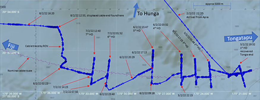
The Reliance then went looking for a repeater — these cost around USD 230,000 each — that was missing between the western and eastern operating areas. Despite three additional HDs, the repeater was not found and a new one was inserted into the replacement section of cable. This replacement section required ~90km of cable and is a patchwork of over half a dozen different spares and recovered bits of cable. Around 40km of cable was recovered from the seafloor, and some of it was used in the repair.
What’s left to do?
Tongatapu is now back online with fibre and no longer needs satellite service, except as a backup in case there are more bumps in the ocean, off which landslides could send turbidity currents in the direction of the freshly restored cable.
The Reliance has since visited the domestic cable grounds. With only around 30km of cable on board but around 80km of cable missing, the ship would have had to recover over well over 50km but has been unable to do so and is now returning to Papua New Guinea. Any new cable is likely to be 6 – 9 months away. Until this stretch of cable can be fixed, the rest of Tonga (particularly Vava’u and Ha’apai that have had service via the domestic cable) will now need satellite service. Much of the satellite capacity directed towards Tongatapu is now being redeployed towards them. This includes most of the 50+ terminals donated by Starlink, which began official service to the terminals shortly after the cable was restored.
With fibre to Tongatapu restored, Tongatapu would present Starlink with a much better location than Fiji to establish a teleport (gateway) from which to provide service into Vava’u, Ha’apai, and the rest of Tonga. Tonga and the rest of the communications world will also need to consider how their networks can be designed with fewer single points of failure and a ready plan for quick recovery should disaster strike again.
Dr Ulrich Speidel is a senior lecturer in Computer Science at the University of Auckland with research interests in fundamental and applied problems in data communications, information theory, signal processing and information measurement. The APNIC Foundation supported his research through its ISIF Asia grants.
Discuss on Hacker NewsThe views expressed by the authors of this blog are their own and do not necessarily reflect the views of APNIC. Please note a Code of Conduct applies to this blog.
Thanks. Coverage!